GIS Module
Integrated GIS mapping for telecoms
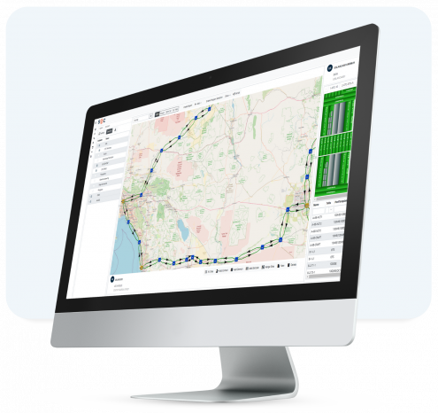
The GIS telecom module offers complete integration of your logical and physical inventory with GIS mapping capabilities and geographic backgrounds

Trusted by:

![]()


![]()
![]()
![]()

![]()
Open and Standardized
The GIS telecom information is based on our own geo-database, while you can select whichever background maps you prefer (such as Google, Bing, OpenStreet Maps, ESRI, or specific government agencies), and is fully aligned with your network inventory.
- Visualize physical (active and passive), logical, virtual assets, workflows and more
- Plot and control all connectivity types, color coded for convenience
- Create complete Bill of Materials for current and planned connections
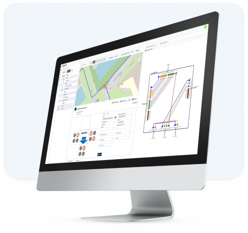
Understand Capacity and Plan More Effectively
With the GIS telecom module, users can select any type of connectivity to understand routes, current capacity, and the impact of changes. Plan new connections, with the optimum path automatically selected to manage costs and accelerate service deployment.
- Create sites, expand views, and measure distances
- Draw new connection paths and align with geo data
- Manage network changes from a single interface

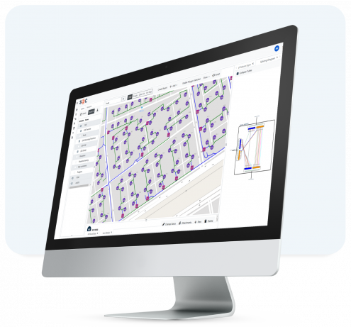
Interactive and Dynamic Network Maps
- Automatic connectivity visualization: Draw connections, services, and equipment based on real-time database information.
- Interactive maps with clickable objects: Open detailed records of equipment, manholes, splice boxes, and other network elements directly from the map.
- Right-click menus provide quick access to object- specific actions and detailed insights.
Sophisticated GIS Features
- Fiber Revision red-lining feature: Mark up and annotate maps for collaborative planning and adjustments.
- Auto-routing: Automatically determine optimal routes through the network, including street- level fiber trench routing.
- 3D Z-position tracking: Register depth and height of cable routes to ensure precision in planning and operations.
- Splicing diagrams and butterfly views: Visualize and manage fiber splicing details and underground infrastructure connections effectively.
- Full support for point-to-point and FTTx/PON networks, including graphical and geographical end-to-end paths.

Outside Plant (OSP) Management
- S2C’s GIS module provides reliable capabilities for managing physical infrastructure assets, including:
- Passive Equipment: Trenches, ducts, fiber/copper cables, manholes, poles, splice boxes, splitters, and cassettes.
- Active Equipment: OLTs, ONTs/ONUs, mobile RAN (2G/3G/4G/5G), microwave, WiFi, MPLS, and more.
- Network Analysis Tools:
- Perform Single Point of Failure (SPOF) analysis to identify vulnerabilities.
- Conduct impact analysis for planned work or faults to assess service disruption.
Warehouse Integration with GIS
.
The GIS module integrates seamlessly with S2C’s warehouse and inventory management system to streamline material handling and resource allocation:
- Link GIS to BOM/BOQ: Generate Bills of Materials and Quantities directly from GIS-planned work orders.
- Track material availability and ensure accurate inventory assignment to specific geographic locations.
- Align warehouse operations with real-time map views, ensuring efficient planning and execution of field tasks.

Enhanced Network Planning and Operations
- Multi-object creation: Create multiple sites, equipment, or connections in one action, with automatic geo-coordinates and templates for configurations.
- Capacity management: Monitor and plan capacity utilization across the network.
- Fault handling and sales support: Use geo-visual insights to resolve issues quickly and identify opportunities for new connections close to existing infrastructure.